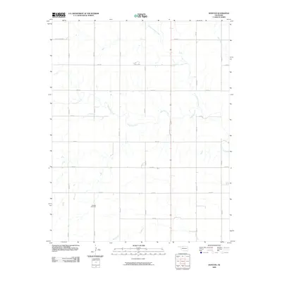
2009 Map of Hopeton
USGS Topo · Published 2009About this map
Eagle Chief Creek meanders across this rural Oklahoma landscape, defining the drainage patterns for the surrounding farmland in Woods County. The area is characterized by a strict section-line road grid, including E0200 Rd and N2430 Rd, which historically organized the settlement and agricultural development of the region. The map captures the subtle water management of the plains, noted by features like the Overton Lake Dam and the convergence of several waterways, including Sand Creek and Little Eagle Chief Creek. These creeks provided essential water sources for early ranching and farming operations. The small community layout is anchored by Main St, representing the central corridor for local commerce and connectivity within the Hopeton quadrangle during the early twenty-first century.
Find a feature on this map
20 named features on this map. Tap any name to fly to it.
Don’t see what you’re looking for? This feature index may not catch every label — zoom into the map to look around manually.
Map Details
Editions of this 2009 Hopeton Map
This is the sole edition of this map. No revisions or reprints were ever made.
Other maps of this area

1955 · Woodward
USGS Topo · 1:250,000

1958 · Woodward
USGS Topo · 1:250,000

1969 · Dacoma
USGS Topo · 1:24,000

1969 · Tegarden SE
USGS Topo · 1:24,000

1969 · Alva SE
USGS Topo · 1:24,000

1969 · Dacoma SW
USGS Topo · 1:24,000

1969 · Hopeton
USGS Topo · 1:24,000

1969 · Avard
USGS Topo · 1:24,000

1969 · Waynoka East
USGS Topo · 1:24,000
1969 · Alva
USGS Topo · 1:24,000