
2012 Map of Hopeton
USGS Topo · Published 2012About this map
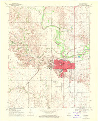
Hopeton serves as the central point of this Woods County survey, situated along Main St amidst a landscape defined by its section-line roads and prairie watercourses. The local geography is etched by the winding paths of Eagle Chief Cr and Little Eagle Chief Cr, which move across the northern and central portions of the quadrangle. In the south, Sand Cr carves through the terrain, illustrating the importance of drainage in this agricultural region. Genealogists will find notable burial grounds including the Avard Cem to the northwest and Pleasant View Cem in the southeast, both of which anchor the rural community. The strict grid of roads, such as E0190 Rd and N2400 Rd, reflects the enduring legacy of the Land Ordinance system on the Oklahoma landscape.
Find a feature on this map
22 named features on this map. Tap any name to fly to it.
Don’t see what you’re looking for? This feature index may not catch every label — zoom into the map to look around manually.
Map Details
Editions of this 2012 Hopeton Map
This is the sole edition of this map. No revisions or reprints were ever made.
Other maps of this area

1955 · Woodward
USGS Topo · 1:250,000

1958 · Woodward
USGS Topo · 1:250,000

1969 · Dacoma
USGS Topo · 1:24,000

1969 · Tegarden SE
USGS Topo · 1:24,000

1969 · Alva SE
USGS Topo · 1:24,000

1969 · Dacoma SW
USGS Topo · 1:24,000

1969 · Hopeton
USGS Topo · 1:24,000

1969 · Avard
USGS Topo · 1:24,000

1969 · Waynoka East
USGS Topo · 1:24,000
1969 · Alva
USGS Topo · 1:24,000