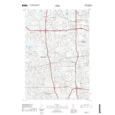
2019 Map of Hopkins
USGS Topo · Published 2019About this map
Minnetonka Mills and the surrounding west-metro suburbs appear here during a period of dense residential and commercial expansion in the late 2010s. The landscape is defined by its glacial history, with numerous water bodies like Medicine Lake, Parkers Lake, and Gleason Lake interspersed between major transportation corridors. Significant arterial routes such as Wayzata Blvd and Excelsior Blvd facilitate the connection between established centers like Hopkins, Plymouth, and Wayzata. Local history is preserved in several sites, including Parkers Lake Cem and the Saint Margaret Cem. The course of Minnehaha Creek winds through the suburban grid, linking smaller lakes like Libbs Lake and Windsor Lake before flowing eastward toward St. Louis Park and Edina. This survey illustrates the intricate balance of high-density development and the natural lacustrine environment of Minnetonka and its neighbors.
Find a feature on this map
51 named features on this map. Tap any name to fly to it.
Don’t see what you’re looking for? This feature index may not catch every label — zoom into the map to look around manually.
Map Details
Editions of this 2019 Hopkins Map
This is the sole edition of this map. No revisions or reprints were ever made.
Other maps of this area

1896 · Minneapolis
USGS Topo · 1:62,500

1901 · Minneapolis
USGS Topo · 1:62,500

1902 · Anoka
USGS Topo · 1:62,500

1905 · Minnetonka
USGS Topo · 1:62,500

1907 · Minnetonka
USGS Topo · 1:62,500

1909 · Rockford
USGS Topo · 1:62,500

1952 · Minneapolis North
USGS Topo · 1:24,000

1952 · Minneapolis South
USGS Topo · 1:24,000

1953 · Saint Paul
USGS Topo · 1:250,000

1953 · Stillwater
USGS Topo · 1:250,000