
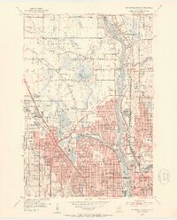
1952 Map of Minneapolis North
USGS Topo · Published 1954About this map
The Mississippi River serves as the central spine for this 1952 topographic survey, dividing the growing northern suburbs of Minneapolis and Columbia Heights from the western settlements. The landscape is a mix of maturing residential grids and industrial development, notably anchored by the Northern Ordnance Plant and the Crystal Airport. The map documents a dense network of civic life through numerous neighborhood schools like Henry High School and Bremer Sch, and parish centers including St Hedwig Sch and Holy Trinity Ch. Significant transit corridors such as the Soo Line and Great Northern railroads trace the riverbanks and cut through the heart of Robbinsdale. To the north, the terrain transitions into more open drainage basins around Palmer Lake and Shingle Creek, showing the early 1950s boundary between established urban areas and the burgeoning township of Brooklyn.
Find a feature on this map
102 named features on this map. Tap any name to fly to it.
Don’t see what you’re looking for? This feature index may not catch every label — zoom into the map to look around manually.
Map Details
Editions of this 1952 Minneapolis North Map
2 editions found
Other maps of this area

1896 · Minneapolis
USGS Topo · 1:62,500

1896 · St. Paul
USGS Topo · 1:62,500

1901 · Minneapolis
USGS Topo · 1:62,500

1902 · White Bear
USGS Topo · 1:62,500

1902 · Anoka
USGS Topo · 1:62,500

1951 · St. Paul West
USGS Topo · 1:24,000

1951 · St. Paul
USGS Topo · 1:62,500

1952 · Minneapolis South
USGS Topo · 1:24,000

1952 · New Brighton
USGS Topo · 1:24,000

1953 · Saint Paul
USGS Topo · 1:250,000