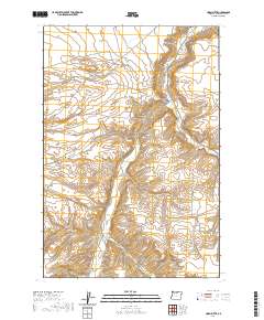
2020 Map of Horn Butte
USGS Topo · Published 2020About this map
Horn Butte stands as a prominent topographical feature in this high plateau region of Gilliam County. The landscape is defined by the sharp incisions of Eightmile Canyon and Fourmile Canyon, which drain toward the drainage of Willow Cr in the northeast. This 2020 survey reveals a quiet, agrarian character where large sections of land, such as Hurlburt Flats, are accessed by a network of rural roads and lanes. Named routes like Sullivan Rd, Rhea Ln, and Taggares Ln suggest a history of family-held land and ranching interests that have persisted through generations in this part of Oregon. The grid of the Public Land Survey System remains the primary framework for navigation across the high desert terrain.
Find a feature on this map
15 named features on this map. Tap any name to fly to it.
Don’t see what you’re looking for? This feature index may not catch every label — zoom into the map to look around manually.
Map Details
Editions of this 2020 Horn Butte Map
This is the sole edition of this map. No revisions or reprints were ever made.
Other maps of this area

1906 · Blalock Island
USGS Topo · 1:125,000

1908 · Blalock Island
USGS Topo · 1:125,000

1916 · Arlington
USGS Topo · 1:125,000

1953 · Pendleton
USGS Topo · 1:250,000

1953 · The Dalles
USGS Topo · 1:250,000

1956 · The Dalles
USGS Topo · 1:250,000

1956 · Pendleton
USGS Topo · 1:250,000

1957 · The Dalles
USGS Topo · 1:250,000

1962 · Alderdale
USGS Topo · 1:24,000

1962 · Heppner Junction
USGS Topo · 1:24,000