1964 Map of Horn Butte
USGS Topo · Published 1965About this map
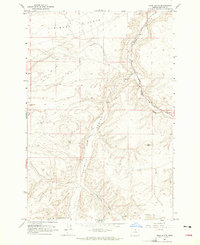
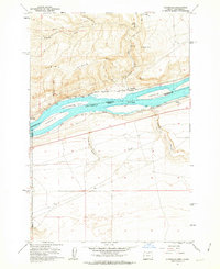
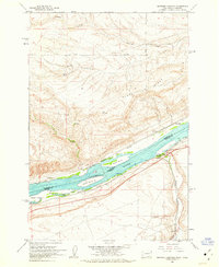
Hurlburt Flats and the deep incisions of Eightmile Canyon define this high plateau landscape in Gilliam County. The map captures a crucial corridor of western migration, clearly marking the path of the Oregon Tr as it traverses the southern sections of the quadrangle. This historic overland route is juxtaposed with the mid-century industrial presence of the Union Pacific railroad, which follows the winding course of Willow Creek through the northeastern corner.
Find a feature on this map
15 named features on this map. Tap any name to fly to it.
Don’t see what you’re looking for? This feature index may not catch every label — zoom into the map to look around manually.
Map Details
Editions of this 1964 Horn Butte Map
This is the sole edition of this map. No revisions or reprints were ever made.
Other maps of this area

1906 · Blalock Island
USGS Topo · 1:125,000

1908 · Blalock Island
USGS Topo · 1:125,000

1916 · Arlington
USGS Topo · 1:125,000

1953 · Pendleton
USGS Topo · 1:250,000

1953 · The Dalles
USGS Topo · 1:250,000

1956 · The Dalles
USGS Topo · 1:250,000

1956 · Pendleton
USGS Topo · 1:250,000

1957 · The Dalles
USGS Topo · 1:250,000
1962 · Alderdale
USGS Topo · 1:24,000
1962 · Heppner Junction
USGS Topo · 1:24,000