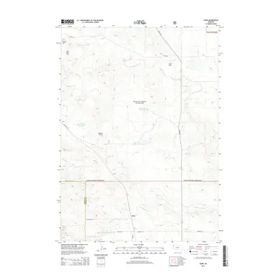
2014 Map of Horn
USGS Topo · Published 2014About this map
Oglala National Grassland dominates this corner of Northwest Nebraska, where the high plains meet the badlands-inflected terrain of the Pine Ridge region. The small settlement of Horn sits at a crossroads near the Sioux Co Dawes Co boundary, serving as a focal point for a landscape defined by ranching and water management. An extensive network of small water catchments, including Dahlheimer Reservoir, Rock Bass Reservoir, and Dodd-McDowell Reservoir, highlights the critical importance of water storage in this semi-arid environment.
Find a feature on this map
25 named features on this map. Tap any name to fly to it.
Don’t see what you’re looking for? This feature index may not catch every label — zoom into the map to look around manually.
Map Details
Editions of this 2014 Horn Map
This is the sole edition of this map. No revisions or reprints were ever made.
Other maps of this area

1955 · Alliance
USGS Topo · 1:250,000

1957 · Alliance
USGS Topo · 1:250,000

1958 · Alliance
USGS Topo · 1:250,000

1980 · Horn
USGS Topo · 1:24,000

1980 · Crow Butte
USGS Topo · 1:24,000

1980 · Wolf Butte
USGS Topo · 1:24,000

1980 · Smiley Canyon
USGS Topo · 1:24,000

1980 · Lone Tree Ranch
USGS Topo · 1:24,000
1980 · Orella
USGS Topo · 1:24,000
1980 · Roundtop
USGS Topo · 1:24,000