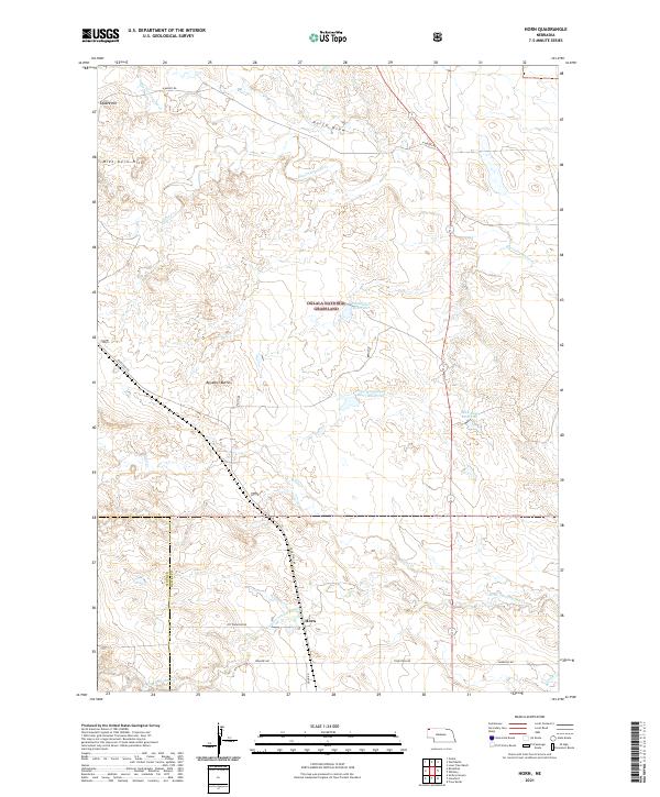
2021 Map of Horn
USGS Topo · Published 2021About this map
The settlement of Horn serves as a focal point in this portion of the Nebraska High Plains, situated at the intersection of Cottonwood Rd and Dodd Rd. This area of the Oglala National Grassland is defined by its complex drainage systems and semi-arid landscape, where water management is critical to local land use. Water features such as the Dahlheimer Reservoir, Rock Bass Reservoir, and Big Cottonwood Allot 1 Reservoir highlight the region's reliance on captured runoff. The terrain is broken by notable landmarks including Benedict Buttes, Square Hill, and the Mike Kern Hills, providing significant relief against the draws and creek beds of Big Cottonwood Cr and Little Cottonwood Cr. This 2021 survey illustrates a sparse settlement pattern connected by named rural routes like Toadstool Rd and Lawrence Rd.
Find a feature on this map
27 named features on this map. Tap any name to fly to it.
Don’t see what you’re looking for? This feature index may not catch every label — zoom into the map to look around manually.
Map Details
Editions of this 2021 Horn Map
This is the sole edition of this map. No revisions or reprints were ever made.
Other maps of this area

1955 · Alliance
USGS Topo · 1:250,000

1957 · Alliance
USGS Topo · 1:250,000

1958 · Alliance
USGS Topo · 1:250,000

1980 · Horn
USGS Topo · 1:24,000

1980 · Crow Butte
USGS Topo · 1:24,000

1980 · Wolf Butte
USGS Topo · 1:24,000

1980 · Smiley Canyon
USGS Topo · 1:24,000

1980 · Lone Tree Ranch
USGS Topo · 1:24,000
1980 · Orella
USGS Topo · 1:24,000
1980 · Roundtop
USGS Topo · 1:24,000