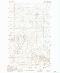
1984 Map of Hornbeck Lake
USGS Topo · Published 1984About this map
Hornbeck Lake and the surrounding drainage basin define this northern Montana landscape in Blaine County. Surveyed by the Geological Survey using 1975 aerial photography, the map reveals a series of seasonal basins and drainage patterns characteristic of the High Plains. The topographical detail focuses on the subtle contours of the plains, where the intermittent flows of West Savoy Creek and East Savoy Creek carve through the land before merging to the south. To the east, Duck Lake sits within a cluster of depressions, illustrating the complex hydrology of this prairie environment. The 1984 edition serves as a record of the region's cattle-country roots, showing the section lines and township boundaries that organized this portion of the northern frontier.
Find a feature on this map
7 named features on this map. Tap any name to fly to it.
Don’t see what you’re looking for? This feature index may not catch every label — zoom into the map to look around manually.
Map Details
Editions of this 1984 Hornbeck Lake Map
This is the sole edition of this map. No revisions or reprints were ever made.
Other maps of this area

1903 · Wayne Creek
USGS Topo · 1:62,500

1905 · Wayne Creek
USGS Topo · 1:62,500

1913 · Cherry Ridge
USGS Topo · 1:125,000

1920 · Avery
USGS Topo · 1:125,000

1953 · Havre
USGS Topo · 1:250,000

1957 · Havre
USGS Topo · 1:250,000

1958 · Havre
USGS Topo · 1:250,000

1964 · Wayne Creek SE
USGS Topo · 1:24,000
1964 · Grable Coulee
USGS Topo · 1:24,000

1984 · Hogeland SE
USGS Topo · 1:24,000