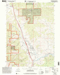
2001 Map of Hornbrook
USGS Topo · Published 2004About this map
Hornbrook and the nearby settlement of Henley sit at a critical transit corridor in Siskiyou County, where the Southern Pacific railroad and major roadways parallel the winding Cottonwood Creek. This survey captures the region as it balanced its industrial past with forest conservation, marked by the extensive boundaries of the Klamath National Forest. Evidence of historical mining is scattered through the drainages, notably at the Jilson Mine Shaft and several tunnels near Rocky Gulch. Cultural memory is anchored by landmarks like the Henley-Hornbrook Cemetery, the B R Alden Historical Marker, and the Jefferson Davis Historical Monument located near Hilt. The landscape is defined by deep gulches such as Rancheria Gulch and Stiffneck Gulch, which feed into the Klamath River at the southern edge of the map, illustrating the drainage patterns that once supported local hydraulic operations.
Find a feature on this map
59 named features on this map. Tap any name to fly to it.
Don’t see what you’re looking for? This feature index may not catch every label — zoom into the map to look around manually.
Map Details
Editions of this 2001 Hornbrook Map
This is the sole edition of this map. No revisions or reprints were ever made.
Other maps of this area

1886 · Shasta
USGS Topo · 1:250,000

1891 · Ashland
USGS Topo · 1:250,000

1893 · Ashland
USGS Topo · 1:250,000

1894 · Shasta
USGS Topo · 1:250,000

1897 · Ashland
USGS Topo · 1:250,000

1922 · Shasta Valley Sheet No 15
USGS Topo · 1:24,000

1922 · Shasta Valley Sheet No 14
USGS Topo · 1:24,000

1932 · Yreka
USGS Topo · 1:96,000

1934 · Macdoel
USGS Topo · 1:96,000

1938 · Medford
USGS Topo · 1:125,000