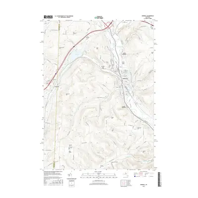
2016 Map of Hornell
USGS Topo · Published 2016About this map
The Canisteo River and its numerous tributaries, including Crosby Cr and Canacadea Cr, define the settlement patterns of this Steuben County corridor. The city of Hornell serves as the central hub, flanked by North Hornell and South Hornell, where the valley floor widens to accommodate both industry and transit. To the west, the village of Almond sits at the base of Pennsylvania Hill, near the waters of Almond Lake. Significant elevation changes are marked by prominent heights such as Newcomb Hill and Hartsville Hill, while the landscape is dotted with numerous burial grounds of genealogical importance, including East Pennsylvania Hill Cem, the Amos White Cem, and Hartsville Center Cem. The presence of specialized landmarks like the Canacadea Creek Bridge and the Canisteo Reservoir highlights the managed water systems critical to this river valley.
Find a feature on this map
137 named features on this map. Tap any name to fly to it.
Don’t see what you’re looking for? This feature index may not catch every label — zoom into the map to look around manually.
Map Details
Editions of this 2016 Hornell Map
This is the sole edition of this map. No revisions or reprints were ever made.
Other maps of this area

1915 · Hornell
USGS Topo · 1:62,500

1916 · Canaseraga
USGS Topo · 1:62,500

1918 · Hornell
USGS Topo · 1:62,500

1926 · Wellsville
USGS Topo · 1:62,500

1926 · Greenwood
USGS Topo · 1:62,500

1940 · Canaseraga
USGS Topo · 1:62,500

1950 · Elmira
USGS Topo · 1:250,000

1954 · South Canisteo
USGS Topo · 1:24,000
1954 · Canisteo
USGS Topo · 1:24,000

1958 · Elmira
USGS Topo · 1:250,000