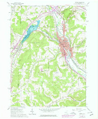
1978 Map of Hornell
USGS Topo · Published 1978About this map
Hornell anchors this Steuben County landscape, positioned at the confluence of Canacadea Creek and the Canisteo River. The city’s mid-century footprint is detailed with civic infrastructure, including the Hornell Sr High School, the Courthouse, and the Library, while the Conrail line parallels the river valley to the southeast. To the west, the Almond Lake reservoir dominates the terrain, created by an earthen dam on the creek. The surrounding uplands are defined by a series of named peaks such as Newcomb Hill and Meeks Hill, interspersed with small rural clusters like Bishopville and Hartsville. Local heritage is reflected in numerous religious and memorial sites, from Temple Beth El and St Anns Church to the Hartsville Hill Cemetery. This period shows the transition of the valley from a heavy rail hub to a landscape featuring a Drive-in Theater, a Golf Course, and significant State Reforestation Areas.
Find a feature on this map
74 named features on this map. Tap any name to fly to it.
Don’t see what you’re looking for? This feature index may not catch every label — zoom into the map to look around manually.
Map Details
Editions of this 1978 Hornell Map
This is the sole edition of this map. No revisions or reprints were ever made.
Other maps of this area

1915 · Hornell
USGS Topo · 1:62,500

1916 · Canaseraga
USGS Topo · 1:62,500

1918 · Hornell
USGS Topo · 1:62,500

1926 · Wellsville
USGS Topo · 1:62,500

1926 · Greenwood
USGS Topo · 1:62,500

1940 · Canaseraga
USGS Topo · 1:62,500

1950 · Elmira
USGS Topo · 1:250,000

1954 · South Canisteo
USGS Topo · 1:24,000
1954 · Canisteo
USGS Topo · 1:24,000

1958 · Elmira
USGS Topo · 1:250,000