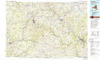
1986 Map of Hornell
USGS Topo · Published 1994About this map
The Canisteo River and Cohocton River valleys define this industrial and educational corridor in the Southern Tier, as it appeared in the mid-1980s. The map captures a region balanced between small-town commerce and academic institutions, notably featuring Alfred University and the State University of New York Agricultural and Technical College at Alfred. Heavy rail activity is evident through the Conrail lines connecting major hubs like Hornell and Corning, while the Bath & Hammondsport RR serves the Finger Lakes transition near Keuka Lake.
Find a feature on this map
80 named features on this map. Tap any name to fly to it.
Don’t see what you’re looking for? This feature index may not catch every label — zoom into the map to look around manually.
Map Details
Editions of this 1986 Hornell Map
2 editions found
Other maps of this area

1895 · Elmira
USGS Topo · 1:62,500

1898 · Watkins Glen
USGS Topo · 1:62,500

1899 · Gaines
USGS Topo · 1:62,500

1900 · Gaines
USGS Topo · 1:62,500

1900 · Tioga
USGS Topo · 1:62,500

1900 · Elkland
USGS Topo · 1:62,500

1900 · Naples
USGS Topo · 1:62,500

1901 · Watkins
USGS Topo · 1:62,500

1902 · Tioga
USGS Topo · 1:62,500

1902 · Ovid
USGS Topo · 1:62,500