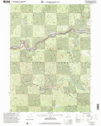
2001 Map of Horse Creek
USGS Topo · Published 2004About this map
The Klamath River carves a central path through this section of the Klamath National Forest, where a Wild and Scenic designation governs its waters. Settlement is concentrated along this river corridor and its tributaries, notably at Horse Creek, Oak Bar, and the Maplesden Ranch. The presence of the Klamath River School and a Cem near the riverbank indicates a persistent community infrastructure amidst the steep terrain.
Find a feature on this map
39 named features on this map. Tap any name to fly to it.
Don’t see what you’re looking for? This feature index may not catch every label — zoom into the map to look around manually.
Map Details
Editions of this 2001 Horse Creek Map
This is the sole edition of this map. No revisions or reprints were ever made.
Other maps of this area

1886 · Shasta
USGS Topo · 1:250,000

1894 · Shasta
USGS Topo · 1:250,000

1914 · Seiad
USGS Topo · 1:125,000

1922 · Seiad
USGS Topo · 1:125,000

1932 · Yreka
USGS Topo · 1:96,000

1939 · Yreka
USGS Topo · 1:125,000

1948 · Weed
USGS Topo · 1:250,000

1950 · Weed
USGS Topo · 1:250,000

1955 · Seiad Valley
USGS Topo · 1:62,500

1955 · Condrey Mtn
USGS Topo · 1:62,500