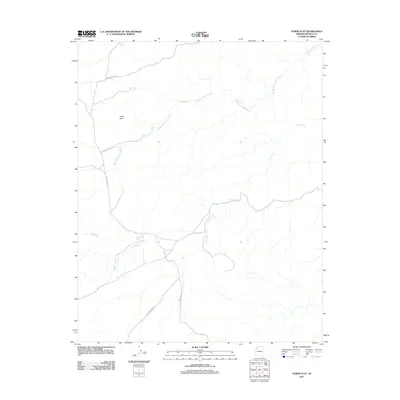
2011 Map of Horse Flat
USGS Topo · Published 2011About this map
Horse Flat and its surrounding high desert landscape in Mohave County are defined by a network of drainage systems and isolated water sources essential for life in this arid region. The drainage patterns of Reference Point Creek and Lost Creek dominate the topography, carving paths through the terrain while seasonal and man-made water catchments like North Horse Flat Tank, Smith Tank, and Clay Tank serve as critical landmarks. A single reliable natural source, Sheep Spring, is situated near the center of the sheet, suggesting its historical importance for livestock or travelers. The transportation network is limited to unpaved access routes including Clay Springs Rd and Buck and Doe Rd, which facilitate movement between the various stock tanks and the open plateau. This 2011 survey records the functional layout of a modern-day ranching or range management area where water security dictates the location of every named feature.
Find a feature on this map
14 named features on this map. Tap any name to fly to it.
Don’t see what you’re looking for? This feature index may not catch every label — zoom into the map to look around manually.
Map Details
Editions of this 2011 Horse Flat Map
This is the sole edition of this map. No revisions or reprints were ever made.
Other maps of this area

1886 · Diamond Creek
USGS Topo · 1:250,000

1892 · Diamond Creek
USGS Topo · 1:250,000

1948 · Williams
USGS Topo · 1:250,000

1954 · Williams
USGS Topo · 1:250,000

1956 · Williams
USGS Topo · 1:250,000

1960 · Williams
USGS Topo · 1:250,000

1961 · Williams
USGS Topo · 1:250,000
1967 · Milkweed Canyon NW
USGS Topo · 1:24,000
1967 · Devils Slide Rapids
USGS Topo · 1:24,000
1967 · Spencer Canyon
USGS Topo · 1:24,000