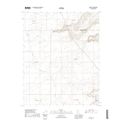
2018 Map of Horse Flat
USGS Topo · Published 2018About this map
Horse Flat and its surrounding canyons define this high-desert landscape in Mohave County, where the U.S. Geological Survey documented critical water resources and drainage patterns. The Northeastern corner of the map contains a portion of the Lake Mead National Recreation Area, where the terrain drops sharply toward Reference Point Creek and the deep incision of Meriwhitica Canyon. This area relies heavily on a network of catchment systems for survival, including Smith Tank, North Horse Flat Tank, and Small Tank, which are essential features in this arid environment.
Find a feature on this map
26 named features on this map. Tap any name to fly to it.
Don’t see what you’re looking for? This feature index may not catch every label — zoom into the map to look around manually.
Map Details
Editions of this 2018 Horse Flat Map
This is the sole edition of this map. No revisions or reprints were ever made.
Other maps of this area

1886 · Diamond Creek
USGS Topo · 1:250,000

1892 · Diamond Creek
USGS Topo · 1:250,000

1948 · Williams
USGS Topo · 1:250,000

1954 · Williams
USGS Topo · 1:250,000

1956 · Williams
USGS Topo · 1:250,000

1960 · Williams
USGS Topo · 1:250,000

1961 · Williams
USGS Topo · 1:250,000
1967 · Milkweed Canyon NW
USGS Topo · 1:24,000
1967 · Devils Slide Rapids
USGS Topo · 1:24,000
1967 · Spencer Canyon
USGS Topo · 1:24,000