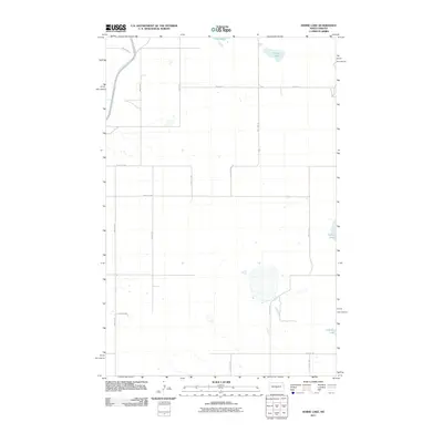
2011 Map of Horse Lake
USGS Topo · Published 2011About this map
Mcclusky Canal cuts through the northwest corner of this Burleigh County landscape, a prominent engineering feature in an otherwise quiet prairie setting. The terrain is defined by scattered water bodies and wetlands, including Horse Lake, Pop Lake, and Pelican Lake, which serve as natural landmarks for the surrounding rural area. A strictly gridded network of section-line roads, such as 184th St NE and 408th Ave NE, organizes the territory into a patchwork of agricultural land. The transition from these local gravel routes to County Hwy 1211 provides the primary infrastructure for the sparsely populated region, illustrating the 21st-century persistence of a historic township-and-range layout. This map records the subtle hydrography of the Northern Plains, from the isolated O'Brien Lake to the artificial path of the canal.
Find a feature on this map
19 named features on this map. Tap any name to fly to it.
Don’t see what you’re looking for? This feature index may not catch every label — zoom into the map to look around manually.
Map Details
Editions of this 2011 Horse Lake Map
This is the sole edition of this map. No revisions or reprints were ever made.
Other maps of this area

1954 · McClusky
USGS Topo · 1:250,000

1958 · McClusky
USGS Topo · 1:250,000

1959 · Pickardville
USGS Topo · 1:24,000

1959 · Mercer SE
USGS Topo · 1:24,000

1959 · McClusky
USGS Topo · 1:24,000

1960 · Horse Lake
USGS Topo · 1:24,000

1960 · Florence Lake
USGS Topo · 1:24,000

1960 · Denhoff
USGS Topo · 1:24,000
1979 · Regan
USGS Topo · 1:24,000

1979 · Canfield Lake
USGS Topo · 1:24,000