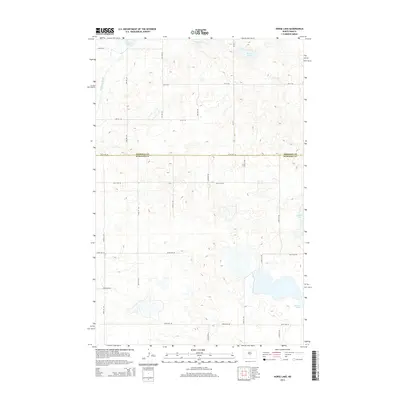
2014 Map of Horse Lake
USGS Topo · Published 2014About this map
The boundary between Sheridan and Burleigh counties bisects this landscape of North Dakota wetlands and prairie depressions. This 2014 survey captures the intricate hydrography of the region, where numerous basins such as Horse Lake, Pelican Lake, and Bunker Lake dot the terrain. The man-made McClusky Canal cuts through the northwestern corner, serving as a prominent engineering feature within the natural prairie pothole environment. Other smaller bodies of water, including Johns Lake and Pop Lake, are interspersed among a structured grid of rural section roads. These thoroughfares, such as 471st Ave NE and 223rd St NE, define the agricultural layout of the high plains, providing a clear window into the late 20th and early 21st-century land management patterns in this part of the state.
Find a feature on this map
25 named features on this map. Tap any name to fly to it.
Don’t see what you’re looking for? This feature index may not catch every label — zoom into the map to look around manually.
Map Details
Editions of this 2014 Horse Lake Map
This is the sole edition of this map. No revisions or reprints were ever made.
Other maps of this area

1954 · McClusky
USGS Topo · 1:250,000

1958 · McClusky
USGS Topo · 1:250,000

1959 · Pickardville
USGS Topo · 1:24,000

1959 · Mercer SE
USGS Topo · 1:24,000

1959 · McClusky
USGS Topo · 1:24,000

1960 · Horse Lake
USGS Topo · 1:24,000

1960 · Florence Lake
USGS Topo · 1:24,000

1960 · Denhoff
USGS Topo · 1:24,000
1979 · Regan
USGS Topo · 1:24,000

1979 · Canfield Lake
USGS Topo · 1:24,000