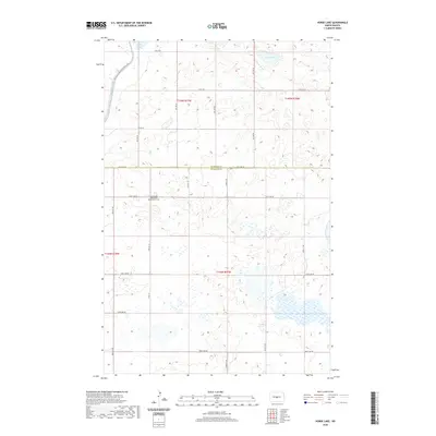
2020 Map of Horse Lake
USGS Topo · Published 2020About this map
Johns Lake Mennonite Brethren Cem sits as a quiet focal point in this portion of the northern plains, marking the cultural and familial history of the area. This landscape straddles the border of Sheridan and Burleigh counties, characterized by numerous small glacial depressions and wetlands typical of the region. The map highlights the prominent Johns Lake and Horse Lake, which are central to the local topography and drainage patterns. A significant modern feature is the McClusky Canal, part of the Garrison Diversion Unit, which cuts through the northern sections of the terrain. For hikers and outdoor enthusiasts, the N Country National Scenic Trail winds through the northwestern corner, providing a narrow corridor of recreational access across the open countryside. The grid of section lines and county roads, including 471st Ave NE, reflects the enduring legacy of the Public Land Survey System.
Find a feature on this map
18 named features on this map. Tap any name to fly to it.
Don’t see what you’re looking for? This feature index may not catch every label — zoom into the map to look around manually.
Map Details
Editions of this 2020 Horse Lake Map
This is the sole edition of this map. No revisions or reprints were ever made.
Other maps of this area

1954 · McClusky
USGS Topo · 1:250,000

1958 · McClusky
USGS Topo · 1:250,000

1959 · Pickardville
USGS Topo · 1:24,000

1959 · Mercer SE
USGS Topo · 1:24,000

1959 · McClusky
USGS Topo · 1:24,000

1960 · Horse Lake
USGS Topo · 1:24,000

1960 · Florence Lake
USGS Topo · 1:24,000

1960 · Denhoff
USGS Topo · 1:24,000
1979 · Regan
USGS Topo · 1:24,000

1979 · Canfield Lake
USGS Topo · 1:24,000