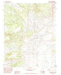
1982 Map of Horse Mesa
USGS Topo · Published 1984About this map
Navajo Indian Reservation lands dominate this borderland landscape, where the high desert terrain of the Red Rock Valley meets the interstate line between Arizona and New Mexico. The map documents a rugged environment defined by seasonal drainages like Blackrock Wash and Red Rock Creek, which carve through the prominent Horse Mesa. Human presence is marked primarily by ranching and resource exploration, evidenced by scattered Corral locations and several Open Pit sites. Essential water sources such as Tse Clani Spring and Oak Spring are critical anchors in this arid region. The presence of multiple Drill Holes and Prospects suggests a mid-to-late 20th-century interest in the mineral potential of these ancestral lands, while the State Boundary Monument 24M provides a precise historical marker of the jurisdictional divide between Apache County and San Juan County.
Find a feature on this map
24 named features on this map. Tap any name to fly to it.
Don’t see what you’re looking for? This feature index may not catch every label — zoom into the map to look around manually.
Map Details
Editions of this 1982 Horse Mesa Map
This is the sole edition of this map. No revisions or reprints were ever made.
Other maps of this area

1889 · Chaco
USGS Topo · 1:250,000

1892 · Chaco
USGS Topo · 1:250,000

1892 · Canyon De Chelly
USGS Topo · 1:250,000

1934 · Ship Rock
USGS Topo · 1:62,500

1934 · Rattlesnake
USGS Topo · 1:62,500

1937 · Ship Rock
USGS Topo · 1:62,500

1937 · Rattlesnake
USGS Topo · 1:62,500

1953 · Redrock Valley NE
USGS Topo · 1:24,000

1953 · Pastora Peak SW
USGS Topo · 1:24,000

1953 · Redrock Valley SE
USGS Topo · 1:24,000