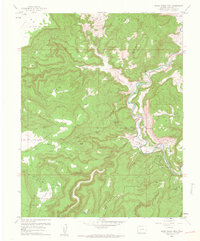
1960 Map of Horse Range Mesa
USGS Topo · Published 1961About this map
Dolores River canyons and high plateau mesas dominate this 1960 landscape in San Miguel County, revealing a region heavily defined by mid-century mineral extraction. The map documents a significant concentration of mining activity, specifically noting the Radium Group Mines, Veta Mad Mine, and the tiered Upper Group Mines, Middle Group Mines, and Lower Group Mines. These operations are clustered near the winding river corridor and along the flanks of Horse Range Mesa.
Find a feature on this map
32 named features on this map. Tap any name to fly to it.
Don’t see what you’re looking for? This feature index may not catch every label — zoom into the map to look around manually.
Map Details
Editions of this 1960 Horse Range Mesa Map
2 editions found
Other maps of this area

1885 · La Sal
USGS Topo · 1:250,000

1886 · Abajo
USGS Topo · 1:250,000

1892 · Abajo
USGS Topo · 1:250,000

1893 · Abajo
USGS Topo · 1:250,000

1916 · Paradox Valley
USGS Topo · 1:125,000

1922 · Paradox Valley
USGS Topo · 1:125,000

1948 · Bull Canyon
USGS Topo · 1:24,000

1948 · Horse Range Mesa
USGS Topo · 1:24,000

1948 · Hamm Canyon
USGS Topo · 1:24,000

1949 · Bull Canyon
USGS Topo · 1:24,000