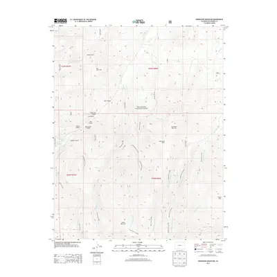
2013 Map of Horseshoe Mountain
USGS Topo · Published 2013About this map
Rio Grande National Forest encompasses this high-elevation landscape, where a dense network of forest service trails and drainages defines the backcountry of Rio Grande County. The topography is dominated by massive landforms such as Horseshoe Mountain and Poison Mountain, separated by high basins like Horseshoe Park and Raton Park. The 2013 survey data captures the modern configuration of access routes, including the West Frisco Trail 850 and Middle Frisco Trail 879, which follow the intricate forks of San Francisco Creek. Numerous named canyons, such as Munger Canyon and Barriclause Canyon, illustrate the deep erosion patterns of the southern Rocky Mountains. This map serves as a vital record for tracing the specific corridors of the forest service system, including the Burro Trail 873 and Bennett Trail 872, as they navigate the ridges and gulches between Pinos Creek and Milk Creek.
Find a feature on this map
42 named features on this map. Tap any name to fly to it.
Don’t see what you’re looking for? This feature index may not catch every label — zoom into the map to look around manually.
Map Details
Editions of this 2013 Horseshoe Mountain Map
This is the sole edition of this map. No revisions or reprints were ever made.
Other maps of this area

1913 · Summitville
USGS Topo · 1:125,000

1914 · Creede
USGS Topo · 1:125,000

1915 · Summitville
USGS Topo · 1:125,000

1915 · Del Norte
USGS Topo · 1:125,000

1916 · Creede
USGS Topo · 1:125,000

1917 · Del Norte
USGS Topo · 1:125,000

1922 · Conejos
USGS Topo · 1:125,000

1945 · Durango
USGS Topo · 1:250,000

1953 · Durango
USGS Topo · 1:250,000

1954 · Durango
USGS Topo · 1:250,000