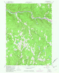
1982 Map of Horton
USGS Topo · Published 1982About this map
The Beaver Kill flows through the northern reaches of this Delaware County landscape, carving a deep valley that serves as the primary corridor for settlements like Peakville, Chiloway, and Horton. This early 1980s revision reveals a terrain defined by high ridges and numerous hollows, where small hamlets and individual homesteads are connected by a network of winding roads such as Burnwood Road and Methol Road. The southern portion of the map is particularly rugged, featuring the Hoffman Forest Preserve and several isolated water bodies including Basket Lake and Glen Lake.
Find a feature on this map
74 named features on this map. Tap any name to fly to it.
Don’t see what you’re looking for? This feature index may not catch every label — zoom into the map to look around manually.
Map Details
Editions of this 1982 Horton Map
This is the sole edition of this map. No revisions or reprints were ever made.
Other maps of this area

1920 · Long Eddy
USGS Topo · 1:62,500

1921 · Long Eddy
USGS Topo · 1:48,000

1921 · Livingston Manor
USGS Topo · 1:62,500

1922 · Andes
USGS Topo · 1:62,500

1923 · Long Eddy
USGS Topo · 1:62,500

1923 · Walton
USGS Topo · 1:48,000

1923 · Livingston Manor
USGS Topo · 1:62,500

1924 · Andes
USGS Topo · 1:62,500

1925 · Walton
USGS Topo · 1:62,500

1943 · Honesdale
USGS Topo · 1:125,000