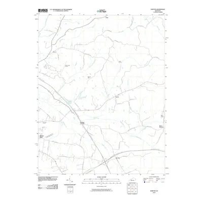
2010 Map of Horton
USGS Topo · Published 2010About this map
Horton and the surrounding Ohio County countryside are defined by a complex network of creeks that feed into the Rough River system. The landscape is marked by the Threelick Fork, North Fork Muddy Creek, and Elmlick Creek, which carve through the terrain near small crossroads like Sandefur Crossing and Jingo. This area shows a pattern of rural settlement where life is centered around family-named landmarks and local burial grounds, such as Taylor Cemetery and Voyles Cemetery.
Find a feature on this map
54 named features on this map. Tap any name to fly to it.
Don’t see what you’re looking for? This feature index may not catch every label — zoom into the map to look around manually.
Map Details
Editions of this 2010 Horton Map
This is the sole edition of this map. No revisions or reprints were ever made.
Other maps of this area

1907 · Whitesville
USGS Topo · 1:62,500

1909 · Whitesville
USGS Topo · 1:62,500

1909 · Hartford
USGS Topo · 1:62,500

1925 · Spring Lick
USGS Topo · 1:62,500

1932 · Fordsville
USGS Topo · 1:62,500

1953 · Dundee
USGS Topo · 1:24,000

1953 · Pleasant Ridge
USGS Topo · 1:24,000

1954 · Evansville
USGS Topo · 1:250,000

1954 · Horton
USGS Topo · 1:24,000
1954 · Paradise
USGS Topo · 1:24,000