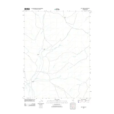
2012 Map of Hot Creek
USGS Topo · Published 2012About this map
Gibbs Ranch and the Anderson Homestead are situated within a high-desert drainage system in Elko County, where early 21st-century ranching life persists along the winding Marys River. The landscape is defined by a dense network of seasonal and perennial waterways, including the namesake Hot Creek and its associated Hot Creek Springs. Evidence of early land claims and grazing operations is seen at Dixons Marys River Ranch, while the surrounding terrain rises toward the Fawn Basin. The intricate web of local drainages such as Wildcat Creek, Willow Creek, and Badger Creek reflects the vital importance of water rights and spring locations, like Bathtub Spring, in this arid Nevada environment. Movement through the area is facilitated by local routes such as Co RD 753, which connects these remote outposts.
Find a feature on this map
17 named features on this map. Tap any name to fly to it.
Don’t see what you’re looking for? This feature index may not catch every label — zoom into the map to look around manually.
Map Details
Editions of this 2012 Hot Creek Map
This is the sole edition of this map. No revisions or reprints were ever made.
Other maps of this area

1955 · Wells
USGS Topo · 1:250,000

1958 · Wells
USGS Topo · 1:250,000

1961 · Wells
USGS Topo · 1:250,000

1967 · Buena Vista Ranch
USGS Topo · 1:24,000

1967 · Black Butte NE
USGS Topo · 1:24,000

1967 · Hanks Creek NE
USGS Topo · 1:24,000

1968 · Marys River Basin NE
USGS Topo · 1:24,000

1968 · Marys River Basin SE
USGS Topo · 1:24,000

1968 · Hot Creek
USGS Topo · 1:24,000
1968 · Stormy Peak
USGS Topo · 1:24,000