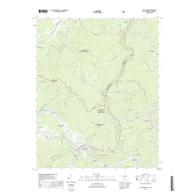
2019 Map of Hot Springs
USGS Topo · Published 2019About this map
The French Broad River carves through the high ridges of the Pisgah National Forest and Cherokee National Forest in this 2019 survey of the North Carolina and Tennessee borderlands. The town of Hot Springs serves as the focal point, situated where the Appalachian National Scenic Trail crosses the river via the Deep Water Bridge. This area, known for its thermal waters, is surrounded by a complex network of ridges like Roundtop Ridge and Mill Ridge, which are defined by numerous gaps including Tanyard Gap and Hurricane Gap.
Find a feature on this map
97 named features on this map. Tap any name to fly to it.
Don’t see what you’re looking for? This feature index may not catch every label — zoom into the map to look around manually.
Map Details
Editions of this 2019 Hot Springs Map
This is the sole edition of this map. No revisions or reprints were ever made.
Other maps of this area

1892 · Greeneville
USGS Topo · 1:125,000

1894 · Asheville
USGS Topo · 1:125,000

1896 · Greeneville
USGS Topo · 1:125,000

1901 · Asheville
USGS Topo · 1:125,000

1904 · Greeneville
USGS Topo · 1:125,000

1935 · Paint Rock
USGS Topo · 1:24,000

1935 · Cedar Creek
USGS Topo · 1:24,000

1935 · Hot Springs
USGS Topo · 1:24,000

1935 · Spring Creek
USGS Topo · 1:24,000

1935 · Lemon Gap
USGS Topo · 1:24,000