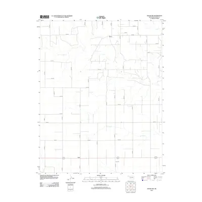
2012 Map of Hough SW
USGS Topo · Published 2012About this map
Hovey and Unity anchor this section of the Oklahoma Panhandle, where the landscape is defined by the section-line road grid and the winding paths of seasonal watercourses. The map tracks the drainage patterns of Goff Cr, Little Goff Cr, and Cow Cr as they cut through the agricultural terrain of Texas County. Local history is centered at the southern end of the quadrangle near Bethel Cem, a key landmark for genealogical research in this rural corridor. The transport network reflects the area's modern connectivity, with primary routes like Co Hwy-40 and Co Hwy-43 facilitating movement across the high plains between these small ranching and farming communities.
Find a feature on this map
34 named features on this map. Tap any name to fly to it.
Don’t see what you’re looking for? This feature index may not catch every label — zoom into the map to look around manually.
Map Details
Editions of this 2012 Hough SW Map
This is the sole edition of this map. No revisions or reprints were ever made.
Other maps of this area

1954 · Perryton
USGS Topo · 1:250,000

1958 · Perryton
USGS Topo · 1:250,000

1973 · Texhoma NE
USGS Topo · 1:24,000

1973 · Goodwell NW
USGS Topo · 1:24,000

1973 · Eva SE
USGS Topo · 1:24,000

1973 · Hough SW
USGS Topo · 1:24,000

1973 · Hough NE
USGS Topo · 1:24,000

1973 · Goodwell NE
USGS Topo · 1:24,000

1973 · Hough NW
USGS Topo · 1:24,000
1973 · Eva NE
USGS Topo · 1:24,000