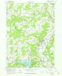
1978 Map of Houghton
USGS Topo · Published 1978About this map
The Genesee River cuts a winding path through this portion of Allegany County, where the valley floor transitions into the elevated terrain of Swift Hill and Taylor Hill. In the late 1970s, this landscape is defined by its educational and recreational hubs, notably Houghton with its prominent Houghton Academy and Houghton College Airfield. To the south, the massive impoundment of Rushford Lake is held by the Caneadea Dam, creating a waterfront community around Balcom Beach and Hillcrest. The map reveals a deep agricultural and transport history, evidenced by an Old Railroad Grade and numerous small settlements like Centerville, Hume, and the aptly named Mills Mills. Genealogists will find several burial grounds across the townships, including Bates Cem and Padonque Cem, alongside landmarks like the Wesleyan Ch and the unique crossing at Lattice Bridge.
Find a feature on this map
61 named features on this map. Tap any name to fly to it.
Don’t see what you’re looking for? This feature index may not catch every label — zoom into the map to look around manually.
Map Details
Editions of this 1978 Houghton Map
This is the sole edition of this map. No revisions or reprints were ever made.
Other maps of this area

1905 · Portage
USGS Topo · 1:62,500

1906 · Angelica
USGS Topo · 1:62,500

1923 · Arcade
USGS Topo · 1:62,500

1924 · Franklinville
USGS Topo · 1:62,500

1925 · Arcade
USGS Topo · 1:62,500

1941 · Angelica
USGS Topo · 1:62,500

1942 · Franklinville
USGS Topo · 1:62,500

1943 · Portageville
USGS Topo · 1:24,000

1943 · Pike
USGS Topo · 1:24,000

1944 · Pike
USGS Topo · 1:31,680