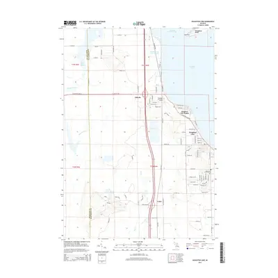
2014 Map of Houghton Lake
USGS Topo · Published 2014About this map
Houghton Lake dominates this northern Michigan landscape, with its western shoreline revealing a complex hydrologic network of marshes and managed waterways. North of Nellsville, the Houghton Lake Flats Flooding and Dead Stream Flooding areas illustrate the significant role of wetland management in this region, while the Muskegon River flows out from the western marshes. The settlement patterns are concentrated along the lake's edge, particularly at Houghton Lake Heights and the community of Houghton Lake, where a dense grid of residential streets like Maple St and Beech St meets the water near Houghton Point. To the south, the landscape transitions into more scattered developments such as Loxley, while the Houghton Lake State Airport and Roscommon Township Cemetery serve as essential local landmarks. This survey captures the area at a time when the economy and geography were firmly centered on the recreational and natural resources of Michigan's largest inland lake.
Find a feature on this map
82 named features on this map. Tap any name to fly to it.
Don’t see what you’re looking for? This feature index may not catch every label — zoom into the map to look around manually.
Map Details
Editions of this 2014 Houghton Lake Map
This is the sole edition of this map. No revisions or reprints were ever made.
Other maps of this area

1954 · Traverse City
USGS Topo · 1:250,000

1956 · Houghton Lake
USGS Topo · 1:62,500

1957 · Harrison
USGS Topo · 1:62,500

1958 · Traverse City
USGS Topo · 1:250,000

1963 · Prudenville
USGS Topo · 1:24,000
1963 · Lyon Manor
USGS Topo · 1:24,000

1969 · Meredith NW
USGS Topo · 1:24,000
1983 · Meads Landing
USGS Topo · 1:25,000

1983 · Moddersville
USGS Topo · 1:25,000
1983 · Addis Creek
USGS Topo · 1:24,000