
1969 Map of Meredith NW
USGS Topo · Published 1971About this map
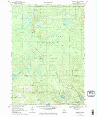
The vast wooded borderlands of the Houghton Lake State Forest and Chippewa River State Forest define this 1969 topographic study. This area on the boundary of Roscommon and Clare counties is characterized by a dense network of glacial lakes and wetlands, including Boyce Lake, Pup Lake, and the remote Lost Lakes. The landscape is etched with the remnants of industrial exploitation, most notably the Old Railroad Grade and the Meredith Grade, which signal the region's logging heritage. Further evidence of resource extraction is found in the Headquarters Oil and Gas Field Road and scattered Gravel Pits, illustrating the shift from timber to mineral and petroleum interests. Small water bodies like Elbow Lake and Trout Lake are connected by numerous watercourses such as Wolf Creek and Townline Creek, creating a complex hydrological pattern across the forested terrain.
Find a feature on this map
27 named features on this map. Tap any name to fly to it.
Don’t see what you’re looking for? This feature index may not catch every label — zoom into the map to look around manually.
Map Details
Editions of this 1969 Meredith NW Map
2 editions found
Other maps of this area

1954 · Traverse City
USGS Topo · 1:250,000

1956 · Houghton Lake
USGS Topo · 1:62,500

1957 · Harrison
USGS Topo · 1:62,500

1958 · Traverse City
USGS Topo · 1:250,000

1963 · Backus Lake
USGS Topo · 1:24,000

1963 · Prudenville
USGS Topo · 1:24,000

1969 · Meredith
USGS Topo · 1:24,000

1969 · Meredith SW
USGS Topo · 1:24,000
1969 · Skeels
USGS Topo · 1:24,000
1983 · Houghton Lake
USGS Topo · 1:25,000