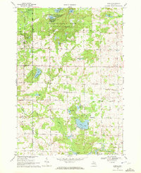
1969 Map of Skeels
USGS Topo · Published 1972About this map
Tittabawassee River State Forest and Skeels State Forest define the wooded character of this northern Michigan landscape at the end of the 1960s. The terrain is defined by a glacial topography of small lakes and marshes, including McGilvery Lake, Pratt Lake, and the uniquely named Greasy Jim Lake. Local settlement is concentrated in small communities like Skeels and Oberlin, while the presence of Meredith in the northwest corner and Podunk in the center suggests the area's rural social fabric. The Cedar River and Little Sugar River wind through the township sections, supporting local drainage and recreation. Notable infrastructure includes the Chappel Dam and several scattered gravel pits, pointing to the local industry and water management of the era. Road networks like Wagarville Road and Stockwell Road provide the primary connections through this forested region of Gladwin County.
Find a feature on this map
55 named features on this map. Tap any name to fly to it.
Don’t see what you’re looking for? This feature index may not catch every label — zoom into the map to look around manually.
Map Details
Editions of this 1969 Skeels Map
This is the sole edition of this map. No revisions or reprints were ever made.
Other maps of this area

1954 · Traverse City
USGS Topo · 1:250,000

1954 · Midland
USGS Topo · 1:250,000

1958 · Traverse City
USGS Topo · 1:250,000

1958 · Midland
USGS Topo · 1:250,000

1959 · Midland
USGS Topo · 1:250,000

1966 · Midland
USGS Topo · 1:250,000

1969 · Meredith NW
USGS Topo · 1:24,000

1969 · Meredith
USGS Topo · 1:24,000

1969 · Butman
USGS Topo · 1:24,000

1969 · Wagarville
USGS Topo · 1:24,000