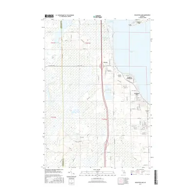
2017 Map of Houghton Lake
USGS Topo · Published 2017About this map
Houghton Lake dominates the eastern half of this landscape, its western shores defined by the prominent Houghton Point and Long Point. The area transitions from the open waters of the lake into extensive wetland systems, including the Houghton Lake Flats Flooding and Dead Stream Flooding, which feed into the headwaters of the Muskegon River. These marshes are a defining characteristic of the Roscommon County terrain, shaped by the local drainage through the Nellsville Ditch.
Find a feature on this map
90 named features on this map. Tap any name to fly to it.
Don’t see what you’re looking for? This feature index may not catch every label — zoom into the map to look around manually.
Map Details
Editions of this 2017 Houghton Lake Map
This is the sole edition of this map. No revisions or reprints were ever made.
Other maps of this area

1954 · Traverse City
USGS Topo · 1:250,000

1956 · Houghton Lake
USGS Topo · 1:62,500

1957 · Harrison
USGS Topo · 1:62,500

1958 · Traverse City
USGS Topo · 1:250,000

1963 · Prudenville
USGS Topo · 1:24,000
1963 · Lyon Manor
USGS Topo · 1:24,000

1969 · Meredith NW
USGS Topo · 1:24,000
1983 · Meads Landing
USGS Topo · 1:25,000

1983 · Moddersville
USGS Topo · 1:25,000
1983 · Addis Creek
USGS Topo · 1:24,000