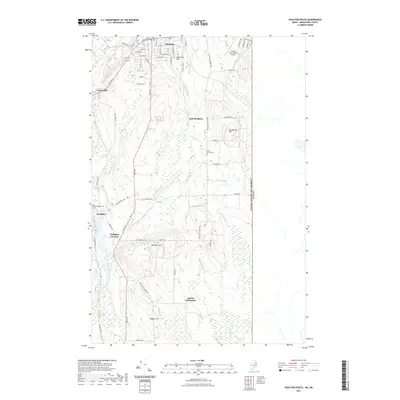
2021 Map of Houlton South
USGS Topo · Published 2021About this map
The Meduxnekeag River and its southern branch wind through this northern borderland, anchoring a landscape defined by small agrarian settlements and the international boundary. In the north, the street grid of Houlton gives way to outlying communities like Carys Mills and East Hodgdon. This 2021 update illustrates the enduring layout of the region's agricultural past, where family-named landmarks like Jackins Settlement and Westford Hill persist alongside modern infrastructure. Notable local history sites include the Union Church Cem and Hodgdon Cem, which sit among a network of brooks such as Pearce Brook and Whirly Brook. The eastern edge of the quadrangle is defined by the straight line of the United States of America Canada border, while the Houlton International Airport serves as a prominent modern landmark near the edge of town.
Find a feature on this map
65 named features on this map. Tap any name to fly to it.
Don’t see what you’re looking for? This feature index may not catch every label — zoom into the map to look around manually.
Map Details
Editions of this 2021 Houlton South Map
This is the sole edition of this map. No revisions or reprints were ever made.
Other maps of this area

1938 · Houlton
USGS Topo · 1:62,500

1940 · Amity
USGS Topo · 1:62,500

1941 · Amity
USGS Topo · 1:62,500

1943 · Amity
USGS Topo · 1:62,500

1951 · Houlton
USGS Topo · 1:62,500

1957 · Fredericton
USGS Topo · 1:250,000
1958 · Amity
USGS Topo · 1:62,500

1959 · Woodstock
USGS Topo · 1:250,000

1963 · Woodstock
USGS Topo · 1:250,000

1963 · Fredericton
USGS Topo · 1:250,000