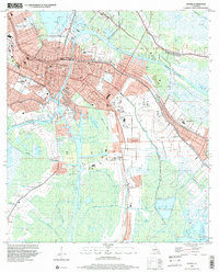
1998 Map of Houma
USGS Topo · Published 2000About this map
The intricate waterways of the Louisiana bayou define the landscape of Houma during the late 1990s, where the city center is bisected by the Houma Intracoastal Waterway and the Houma Navigation Canal. This survey illustrates the dense residential layout of neighborhoods like East Houma and Daigleville alongside industrial infrastructure, including the Houma Gas Field and the Houma-Terrebonne Airport. For genealogists, the map is a detailed guide to local burial grounds and parish landmarks, showing Myrtle Grove Cem, Crozier Cem, and St John Ch. The transition from urban streets like Main St to the marshy lowlands of Bayou Grand Caillou and Bayou La Carpe reveals the region's reliance on both water navigation and land reclamation, with numerous drainage canals such as Ashland Canal and Goudreaux Canal supporting the surrounding settlements.
Find a feature on this map
104 named features on this map. Tap any name to fly to it.
Don’t see what you’re looking for? This feature index may not catch every label — zoom into the map to look around manually.
Map Details
Editions of this 1998 Houma Map
This is the sole edition of this map. No revisions or reprints were ever made.
Other maps of this area

1892 · Gibson
USGS Topo · 1:62,500

1892 · Houma
USGS Topo · 1:62,500

1894 · Bayou De Large
USGS Topo · 1:62,500

1894 · Dulac
USGS Topo · 1:62,500

1897 · Gibson
USGS Topo · 1:62,500

1932 · Houma SE
USGS Topo · 1:31,680

1932 · Houma SW
USGS Topo · 1:31,680

1932 · Houma NE
USGS Topo · 1:31,680

1932 · Houma NW
USGS Topo · 1:31,680

1935 · Theriot
USGS Topo · 1:31,680