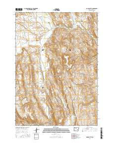
2017 Map of House Butte
USGS Topo · Published 2017About this map
House Butte rises as a central landmark in this high-desert landscape of eastern Oregon, situated within the Stinkingwater Mountains. The terrain is defined by a network of drainage systems and springs, including Renfro Springs and King Spring, which feed into the Malheur River in the northern portion of the quadrangle. Early 21st-century water management is evident through various impoundments such as Sitz Reservoir, Van Derveer Reservoir, and Rimrock Reservoir, as well as historic irrigation features like Robbins Ditch and Miller Ditch.
Find a feature on this map
38 named features on this map. Tap any name to fly to it.
Don’t see what you’re looking for? This feature index may not catch every label — zoom into the map to look around manually.
Map Details
Editions of this 2017 House Butte Map
This is the sole edition of this map. No revisions or reprints were ever made.
Other maps of this area

1955 · Burns
USGS Topo · 1:250,000

1958 · Burns
USGS Topo · 1:250,000

1959 · Burns
USGS Topo · 1:250,000

1968 · Drewsey
USGS Topo · 1:62,500

1968 · Van
USGS Topo · 1:62,500

1973 · Buchanan
USGS Topo · 1:24,000
1977 · Bartlett Mtn
USGS Topo · 1:24,000
1978 · Stinkingwater Pass
USGS Topo · 1:24,000

1978 · Stinkingwater Mountains
USGS Topo · 1:100,000
1990 · Otis Mountain
USGS Topo · 1:24,000