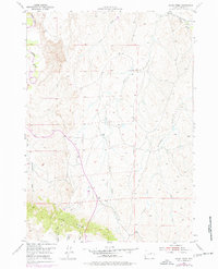
1954 Map of House Creek
USGS Topo · Published 1977About this map
The Bozeman Trail cuts across the northeastern corner of this high plains landscape, following the path of the Dry Fork Powder River. This 1950s survey, updated in the early 1970s, documents a rugged section of Johnson County defined by complex drainage systems and the prominent elevation of Pine Ridge. The geography is characterized by numerous named draws, such as School Draw, Frenchman Draw, and Carpenter Draw, which feed into larger watercourses like House Creek and Bullwhacker Creek. In the northwest, the Powder River meanders through the terrain, its banks and surrounding bluffs providing a detailed look at the hydrology of the region before modern developments altered many Western landscapes. The map serves as a precise record of historical routes and natural landmarks in a sparsely populated ranching and transition area.
Find a feature on this map
14 named features on this map. Tap any name to fly to it.
Don’t see what you’re looking for? This feature index may not catch every label — zoom into the map to look around manually.
Map Details
Editions of this 1954 House Creek Map
3 editions found
Other maps of this area

1953 · Dry Fork Ranch
USGS Topo · 1:24,000

1953 · Fort Reno
USGS Topo · 1:24,000

1953 · Fort Reno SE
USGS Topo · 1:24,000

1954 · House Creek
USGS Topo · 1:24,000

1954 · Linch
USGS Topo · 1:24,000

1954 · Taylor Ranch
USGS Topo · 1:24,000

1955 · Arminto
USGS Topo · 1:250,000

1958 · Arminto
USGS Topo · 1:250,000

1961 · Soldier Creek
USGS Topo · 1:24,000

1961 · Dead Woman Crossing
USGS Topo · 1:24,000