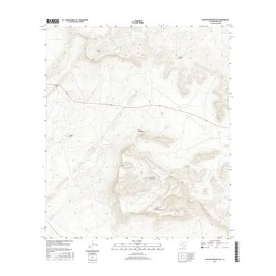
2016 Map of Housetop Mountains
USGS Topo · Published 2016About this map
The Housetop Mountains dominate this high-desert landscape in Brewster County, where the topography is defined by dramatic elevation shifts and seasonal water drainage patterns. Steep ridges and peaks like Spencer Mtn tower over a series of deep cuts and canyons, most notably the Fin Del Mundo Canyon. These landforms dictate the flow of ephemeral water, with Willow Cr and Dry Cr cutting through the terrain. Evidence of ranching and land use is found in labels such as Eighty Tank Draw and Red Mill Draw, indicating locations where water was historically managed or mills once stood.
Find a feature on this map
10 named features on this map. Tap any name to fly to it.
Don’t see what you’re looking for? This feature index may not catch every label — zoom into the map to look around manually.
Map Details
Editions of this 2016 Housetop Mountains Map
This is the sole edition of this map. No revisions or reprints were ever made.
Other maps of this area

1920 · Longfellow
USGS Topo · 1:125,000

1920 · Marathon
USGS Topo · 1:62,500

1921 · Marathon
USGS Topo · 1:62,500

1923 · Hess Canyon
USGS Topo · 1:62,500

1954 · Fort Stockton
USGS Topo · 1:250,000

1958 · Fort Stockton
USGS Topo · 1:250,000
1967 · Horse Mountain
USGS Topo · 1:24,000

1968 · Housetop Mountains
USGS Topo · 1:24,000

1968 · Tesnus
USGS Topo · 1:24,000

1968 · Cap Rock Butte
USGS Topo · 1:24,000