
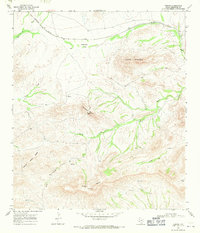
1968 Map of Tesnus
USGS Topo · Published 1971About this map
The Southern Pacific railroad cuts through the northern high desert landscape of Brewster County, providing the primary infrastructure for this remote ranching and transit area. The settlement of Tesnus serves as a key waypoint along the line, positioned just east of the Copeland Trap and the prominent rising face of Castle Mountain. The topography is defined by significant elevation changes, ranging from the intricate drainage systems of China Draw and Negro Creek to the jagged elevations of Panther Peaks and Shely Peaks.
Find a feature on this map
16 named features on this map. Tap any name to fly to it.
Don’t see what you’re looking for? This feature index may not catch every label — zoom into the map to look around manually.
Map Details
Editions of this 1968 Tesnus Map
2 editions found
Other maps of this area

1917 · Hood Spring
USGS Topo · 1:62,500

1918 · Bone Spring
USGS Topo · 1:125,000

1918 · Hood Spring
USGS Topo · 1:62,500

1918 · Dove Mountain
USGS Topo · 1:62,500

1920 · Longfellow
USGS Topo · 1:125,000

1920 · Marathon
USGS Topo · 1:62,500

1921 · Marathon
USGS Topo · 1:62,500

1931 · Hood Spring
USGS Topo · 1:62,500

1954 · Fort Stockton
USGS Topo · 1:250,000

1958 · Fort Stockton
USGS Topo · 1:250,000