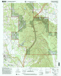
2000 Map of Houston East
USGS Topo · Published 2002About this map
The Tombigbee National Forest dominates the landscape of this area at the turn of the millennium, with the modern Natchez Trace Parkway cutting a diagonal path through its pine and hardwood stands. Significant historical layers are preserved here, including the ancient Bynum Mounds and the smaller settlements of Van Vleet and Parkersburg. This map reveals a high concentration of family and community cemeteries, such as Ross Hill Cem, Witch Dance Cem, and Morgan Cem, reflecting generations of rural Chickasaw County residents. The periphery of Houston appears in the southwest corner, showcasing 20th-century developments like the Chickasaw Co Coliseum, the Golf Course, and a Drive-in Theater. The landscape is defined by the winding paths of Houlka Creek and Soetahoma Creek, alongside evidence of local extraction at numerous Sandpits.
Find a feature on this map
47 named features on this map. Tap any name to fly to it.
Don’t see what you’re looking for? This feature index may not catch every label — zoom into the map to look around manually.
Map Details
Editions of this 2000 Houston East Map
This is the sole edition of this map. No revisions or reprints were ever made.
Other maps of this area

1953 · West Point
USGS Topo · 1:250,000

1956 · Tupelo
USGS Topo · 1:250,000

1958 · Tupelo
USGS Topo · 1:250,000

1958 · West Point
USGS Topo · 1:250,000

1959 · Van Vleet
USGS Topo · 1:62,500

1963 · West Point
USGS Topo · 1:250,000

1966 · Troy SE
USGS Topo · 1:24,000

1966 · Troy
USGS Topo · 1:24,000

1972 · Houlka
USGS Topo · 1:24,000
1972 · Houston West
USGS Topo · 1:24,000