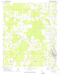
1972 Map of Houston West
USGS Topo · Published 1974About this map
The Yalobusha River and its intricate network of tributaries, including Fourmile Creek and Mud Creek, define the rural landscape of Chickasaw County as it appeared in the early 1970s. The western outskirts of Houston serve as the primary hub, where the Houston Municipal Airport and Radio Towers (WCPC) stand alongside the Illinois Central Gulf railroad. This line, a critical artery for the regional economy, parallels several creeks and serves the local agriculture and timber interests of the era.
Find a feature on this map
24 named features on this map. Tap any name to fly to it.
Don’t see what you’re looking for? This feature index may not catch every label — zoom into the map to look around manually.
Map Details
Editions of this 1972 Houston West Map
This is the sole edition of this map. No revisions or reprints were ever made.
Other maps of this area

1953 · West Point
USGS Topo · 1:250,000

1956 · Tupelo
USGS Topo · 1:250,000

1958 · Tupelo
USGS Topo · 1:250,000

1958 · West Point
USGS Topo · 1:250,000

1959 · Van Vleet
USGS Topo · 1:62,500

1963 · West Point
USGS Topo · 1:250,000

1966 · Troy
USGS Topo · 1:24,000

1972 · Houlka
USGS Topo · 1:24,000

1972 · Robbs
USGS Topo · 1:24,000

1972 · Atlanta
USGS Topo · 1:24,000