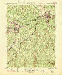
1947 Map of Houtzdale
USGS Topo · Published 1947About this map
Houtzdale and the surrounding coal settlements of the Allegheny Mountains are captured during a mid-century era of heavy industrial activity. The landscape is defined by the dense network of the Pennsylvania railroad system, which connects mining hamlets like Brisbin, Sterling, and West Moshannon. The intricate rail spurs follow the contours of the land, specifically tracing Beaver Run and Moshannon Creek to reach coal-loading points like Goss Run Junction and Coal Run Junction. Local civic life is anchored by schools such as Ocean School and Beaver School, while the larger hub of Osceola Mills serves as a primary post office and station for the region. The map illustrates a high degree of integration between industrial transport and the township divisions of Woodward, Gulich, and Rush.
Find a feature on this map
46 named features on this map. Tap any name to fly to it.
Don’t see what you’re looking for? This feature index may not catch every label — zoom into the map to look around manually.
Map Details
Editions of this 1947 Houtzdale Map
This is the sole edition of this map. No revisions or reprints were ever made.
Other maps of this area

1903 · Houtzdale
USGS Topo · 1:62,500

1905 · Houtzdale
USGS Topo · 1:62,500

1920 · Altoona
USGS Topo · 1:62,500

1922 · Philipsburg
USGS Topo · 1:62,500

1922 · Altoona
USGS Topo · 1:62,500

1923 · Tyrone
USGS Topo · 1:62,500

1929 · Tyrone
USGS Topo · 1:48,000

1933 · Tyrone
USGS Topo · 1:62,500

1939 · Philipsburg
USGS Topo · 1:62,500

1944 · Houtzdale
USGS Topo · 1:24,000