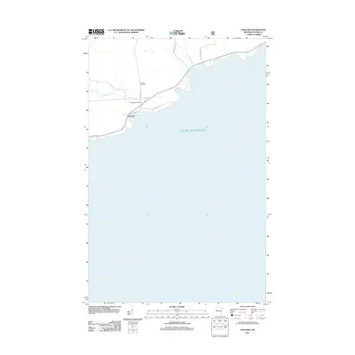
2011 Map of Hovland
USGS Topo · Published 2011About this map
Hovland occupies a prominent position on the North Shore of Lake Superior, where the Flute Reed River meets the lake's rocky coastline. This 2011 survey illustrates the modern layout of this coastal settlement, defined by the junction of County Hwy 69 and the historic Arrowhead Tr. For genealogists and local historians, the presence of the Old Settlers Cemetery along North Rd serves as a critical link to the community's early families and pioneer heritage. The landscape is marked by several watercourses including Carlson Creek and roads with descriptive names like Moose Valley Rd and Whippoorwill Ln, which trace the interior highlands. Public facilities such as the Hovland Rest Area highlight the community's role as a waypoint for travelers navigating this remote stretch of the Minnesota shoreline.
Find a feature on this map
12 named features on this map. Tap any name to fly to it.
Don’t see what you’re looking for? This feature index may not catch every label — zoom into the map to look around manually.
Map Details
Editions of this 2011 Hovland Map
This is the sole edition of this map. No revisions or reprints were ever made.
Other maps of this area

1954 · Two Harbors
USGS Topo · 1:250,000

1957 · Two Harbors
USGS Topo · 1:250,000

1958 · Two Harbors
USGS Topo · 1:250,000

1958 · Hancock
USGS Topo · 1:250,000

1959 · Mineral Center
USGS Topo · 1:24,000

1959 · Tom Lake
USGS Topo · 1:24,000

1960 · Hancock
USGS Topo · 1:250,000
1960 · Farquhar Peak
USGS Topo · 1:24,000
1960 · Hovland
USGS Topo · 1:24,000
1960 · Marr Island
USGS Topo · 1:24,000