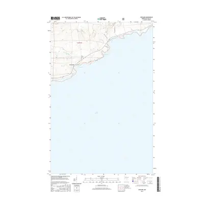
2016 Map of Hovland
USGS Topo · Published 2016About this map
Hovland anchors this 2016 survey along the North Shore of Lake Superior, where the woodland interior meets the vast expanse of the water. The settlement is defined by its relationship to the lake, situated at the mouth of the Flute Reed River near the sheltering curve of Chicago Bay. This map provides significant genealogical value for the area, specifically identifying the Old Settlers Cem north of the main coastal route. The landscape is characterized by a series of prominent coastal features, including Big Bay, Horseshoe Bay, and the jutting landform of Big Bay Pt. Further inland, the terrain is navigated by local arteries such as Chicago Bay Rd and Moose Valley Rd, while Carlson Cr drains the higher elevations to the east. The map captures a contemporary view of this Cook County shoreline, balancing modern local roads with longstanding geographic landmarks.
Find a feature on this map
17 named features on this map. Tap any name to fly to it.
Don’t see what you’re looking for? This feature index may not catch every label — zoom into the map to look around manually.
Map Details
Editions of this 2016 Hovland Map
This is the sole edition of this map. No revisions or reprints were ever made.
Other maps of this area

1954 · Two Harbors
USGS Topo · 1:250,000

1957 · Two Harbors
USGS Topo · 1:250,000

1958 · Two Harbors
USGS Topo · 1:250,000

1958 · Hancock
USGS Topo · 1:250,000

1959 · Mineral Center
USGS Topo · 1:24,000

1959 · Tom Lake
USGS Topo · 1:24,000

1960 · Hancock
USGS Topo · 1:250,000
1960 · Farquhar Peak
USGS Topo · 1:24,000
1960 · Hovland
USGS Topo · 1:24,000
1960 · Marr Island
USGS Topo · 1:24,000