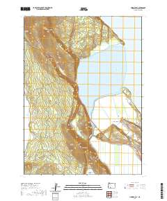
2020 Map of Howard Bay
USGS Topo · Published 2020About this map
Upper Klamath Lake dominates this 2020 landscape in Klamath County, Oregon, where the water meets the steep slopes of Spence Mtn and Doaks Mtn. The shoreline here is defined by significant wetland areas and reclamation history, visible in the extensive Sesti Tgawaals Marsh and the larger Caledonia Marsh. These lowlands are managed through a network of infrastructure including the Caledonia Canal and the Wocus-Drainage-Canal, reflecting a long-standing regional focus on irrigation and land use.
Find a feature on this map
31 named features on this map. Tap any name to fly to it.
Don’t see what you’re looking for? This feature index may not catch every label — zoom into the map to look around manually.
Map Details
Editions of this 2020 Howard Bay Map
This is the sole edition of this map. No revisions or reprints were ever made.
Other maps of this area

1889 · Klamath
USGS Topo · 1:250,000

1891 · Ashland
USGS Topo · 1:250,000

1893 · Ashland
USGS Topo · 1:250,000

1894 · Klamath
USGS Topo · 1:250,000

1897 · Ashland
USGS Topo · 1:250,000

1955 · Lake O' Woods
USGS Topo · 1:62,500

1955 · Surveyor Mtn
USGS Topo · 1:62,500

1955 · Klamath Falls
USGS Topo · 1:250,000

1955 · Medford
USGS Topo · 1:250,000

1957 · Medford
USGS Topo · 1:250,000