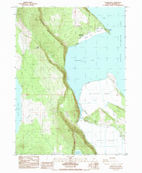
1985 Map of Howard Bay
USGS Topo · Published 1985About this map
Upper Klamath Lake defines the eastern shoreline of this landscape, where the waters of Howard Bay meet a complex system of dikes and levees. In the mid-1980s, the transition from the steep timbered slopes of Spence Mountain and Doaks Mountain to the reclaimed agricultural lands of Caledonia Marsh illustrates a significant history of water management. The infrastructure of the basin is clearly visible, including a Pumping Station and several water control structures like the Cross Dike and Road on Levee.
Find a feature on this map
28 named features on this map. Tap any name to fly to it.
Don’t see what you’re looking for? This feature index may not catch every label — zoom into the map to look around manually.
Map Details
Editions of this 1985 Howard Bay Map
This is the sole edition of this map. No revisions or reprints were ever made.
Other maps of this area

1889 · Klamath
USGS Topo · 1:250,000

1891 · Ashland
USGS Topo · 1:250,000

1893 · Ashland
USGS Topo · 1:250,000

1894 · Klamath
USGS Topo · 1:250,000

1897 · Ashland
USGS Topo · 1:250,000

1955 · Lake O' Woods
USGS Topo · 1:62,500

1955 · Surveyor Mtn
USGS Topo · 1:62,500

1955 · Klamath Falls
USGS Topo · 1:250,000

1955 · Medford
USGS Topo · 1:250,000

1957 · Medford
USGS Topo · 1:250,000