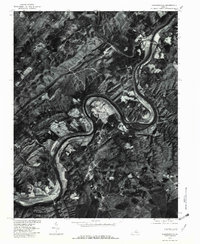
1979 Map of Howardsville
USGS Topo · Published 1982About this map
The James River carves a dramatic S-curve through the heart of this Virginia landscape, defining the boundaries and transportation corridors of the late 1970s. Along its banks, the small settlements of Howardsville and Warminster mark historical crossing and landing points where the river meets significant tributaries like the Rockfish River. This orthophotograph, prepared from 1979 aerial imagery, provides a clear view of the agricultural patterns and dense woodlands that characterized the region. To the southwest, the community of Wingina sits near the river bend, while Midway Mills and Grays occupy the higher ground and stream valleys inland. The detailed imagery reveals the placement of homesteads and rural roads relative to the drainage of Beaver Creek and Sycamore Creek, offering an unfiltered look at the rural Piedmont's spatial organization before modern development expanded.
Find a feature on this map
9 named features on this map. Tap any name to fly to it.
Don’t see what you’re looking for? This feature index may not catch every label — zoom into the map to look around manually.
Map Details
Editions of this 1979 Howardsville Map
This is the sole edition of this map. No revisions or reprints were ever made.
Other maps of this area

1892 · Buckingham
USGS Topo · 1:125,000

1929 · Covesville
USGS Topo · 1:62,500

1935 · Covesville
USGS Topo · 1:62,500

1943 · Lovingston
USGS Topo · 1:62,500

1945 · Covesville
USGS Topo · 1:62,500

1946 · Lovingston
USGS Topo · 1:62,500

1947 · Roanoke
USGS Topo · 1:250,000

1959 · Roanoke
USGS Topo · 1:250,000

1961 · Shipman
USGS Topo · 1:62,500

1961 · Buckingham
USGS Topo · 1:62,500