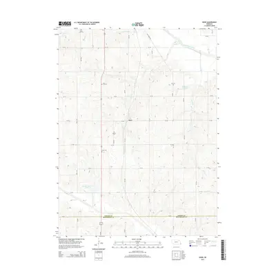
2014 Map of Howe
USGS Topo · Published 2014About this map
The settlement of Howe serves as the focal point for this Southeast Nebraska landscape, situated within a dense network of sectional roads and watercourses. Genealogists will find the area particularly notable for its high concentration of rural burial grounds, including Saint Pauls Cem, Holy Cross Cem, Bedford Cem, Kite Cem, and Howell Cem. These sites are scattered across the rolling terrain between the Little Nemaha River to the north and the border shared by Nemaha Co and Richardson Co to the south. The drainage patterns of Codington Cr and Hughes Cr feed into the river system, while managed water resources like Bergmann Reservoir and Muddy Cr Reservoir Number 10 indicate the agricultural importance of water management in the region. A historically significant label, Half Breed Rd, hints at the complex early surveying and land grant history unique to this portion of Nebraska.
Find a feature on this map
24 named features on this map. Tap any name to fly to it.
Don’t see what you’re looking for? This feature index may not catch every label — zoom into the map to look around manually.
Map Details
Editions of this 2014 Howe Map
This is the sole edition of this map. No revisions or reprints were ever made.
Other maps of this area

1915 · Falls City
USGS Topo · 1:62,500

1915 · Nemaha
USGS Topo · 1:62,500

1915 · Howe
USGS Topo · 1:62,500

1916 · Humboldt
USGS Topo · 1:62,500

1939 · Nemaha
USGS Topo · 1:62,500

1949 · Nemaha
USGS Topo · 1:62,500

1955 · Nebraska City
USGS Topo · 1:250,000

1957 · Nebraska City
USGS Topo · 1:250,000

1958 · Nebraska City
USGS Topo · 1:250,000
1965 · Dawson
USGS Topo · 1:24,000