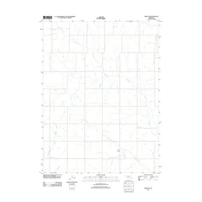
2011 Map of Howe SW
USGS Topo · Published 2011About this map
The agricultural landscape of southeast Nebraska is defined here by the winding course of Muddy Creek and its tributaries, which dictate the placement of rural roads and homesteads. This 2011 survey captures the area's organized section lines occasionally yielding to the natural path of Little Muddy Creek as it meanders toward the southeast corner. Located in a central position above the creek's southern fork is the Pleasant View Cemetery, a key site for local genealogical research that remains a focal point for the surrounding farm community. To the northeast, the terrain is marked by the Scotch Branch drainage, completing a network of waterways that has shaped the drainage and land-use patterns of this Richardson County region for generations.
Find a feature on this map
4 named features on this map. Tap any name to fly to it.
Don’t see what you’re looking for? This feature index may not catch every label — zoom into the map to look around manually.
Map Details
Editions of this 2011 Howe SW Map
This is the sole edition of this map. No revisions or reprints were ever made.
Other maps of this area

1915 · Howe
USGS Topo · 1:62,500

1916 · Humboldt
USGS Topo · 1:62,500

1955 · Nebraska City
USGS Topo · 1:250,000

1955 · Lincoln
USGS Topo · 1:250,000

1957 · Nebraska City
USGS Topo · 1:250,000

1957 · Lincoln
USGS Topo · 1:250,000

1958 · Lincoln
USGS Topo · 1:250,000

1958 · Nebraska City
USGS Topo · 1:250,000

1965 · Table Rock
USGS Topo · 1:24,000
1965 · Tecumseh SE
USGS Topo · 1:24,000