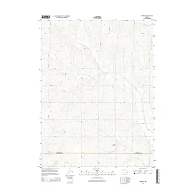
2014 Map of Howe SW
USGS Topo · Published 2014About this map
Pleasant View Cem sits as a solitary local landmark in this agrarian landscape of southeast Nebraska, just north of the Nemaha Co and Richardson Co boundary. The terrain is defined by a dense network of watercourses, where Muddy Cr and its tributary Little Muddy Cr wind through the hills alongside Longs Cr and Scotch Br. The map reveals the rigid section lines of the rural road system, from north-south corridors like 634 Ave to east-west routes such as 720 Rd. This 2014 survey documents a classic Midwestern agricultural pattern where traditional watercourse-influenced land use meets the precision of the Public Land Survey System, providing a clear record of the area's rural infrastructure and cemeteries for family historians.
Find a feature on this map
21 named features on this map. Tap any name to fly to it.
Don’t see what you’re looking for? This feature index may not catch every label — zoom into the map to look around manually.
Map Details
Editions of this 2014 Howe SW Map
This is the sole edition of this map. No revisions or reprints were ever made.
Other maps of this area

1915 · Howe
USGS Topo · 1:62,500

1916 · Humboldt
USGS Topo · 1:62,500

1955 · Nebraska City
USGS Topo · 1:250,000

1955 · Lincoln
USGS Topo · 1:250,000

1957 · Nebraska City
USGS Topo · 1:250,000

1957 · Lincoln
USGS Topo · 1:250,000

1958 · Lincoln
USGS Topo · 1:250,000

1958 · Nebraska City
USGS Topo · 1:250,000

1965 · Table Rock
USGS Topo · 1:24,000
1965 · Tecumseh SE
USGS Topo · 1:24,000