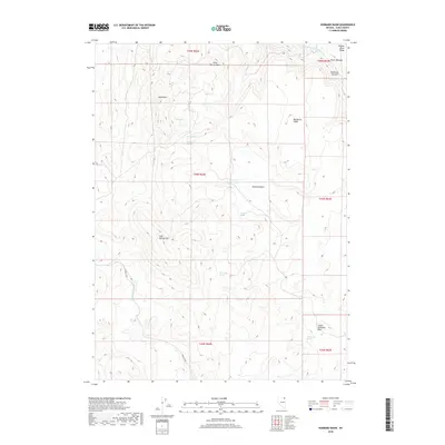
2018 Map of Hubbard Basin
USGS Topo · Published 2018About this map
Hubbard Basin and the adjacent Lower Hubbard Basin characterize this high-desert landscape in northeast Nevada. The terrain is defined by a series of distinct flat-topped mesas, including Little Devils Table and Big Devils Table, which rise above the surrounding drainages. Water management is central to the area's utility, evidenced by the presence of Corner Reservoir and a high concentration of named water sources such as Leo Spring, Wrist Spring, and Twin Ledge Spring.
Find a feature on this map
26 named features on this map. Tap any name to fly to it.
Don’t see what you’re looking for? This feature index may not catch every label — zoom into the map to look around manually.
Map Details
Editions of this 2018 Hubbard Basin Map
This is the sole edition of this map. No revisions or reprints were ever made.
Other maps of this area

1955 · Wells
USGS Topo · 1:250,000

1957 · Contact
USGS Topo · 1:62,500

1957 · Elk Mountain
USGS Topo · 1:62,500

1958 · Wells
USGS Topo · 1:250,000

1961 · Wells
USGS Topo · 1:250,000

1968 · Hubbard Basin
USGS Topo · 1:24,000

1968 · Henry
USGS Topo · 1:24,000
1968 · Harris Canyon
USGS Topo · 1:24,000
1968 · Boies Reservoir
USGS Topo · 1:24,000
1968 · Stormy Peak
USGS Topo · 1:24,000